
Professional Services with Bozmaps

Mapping with Bozmaps
Bozmaps specialises in providing expert GIS services, including data capture, spatial analysis, workflow and database design, data cleaning, remote sensing, and tailored training solutions. Our team is dedicated to helping organizations harness the power of geospatial data for informed decision-making, enhanced efficiency, and strategic planning.

Online Training
OGC Standard


UK based
Bozmaps Services


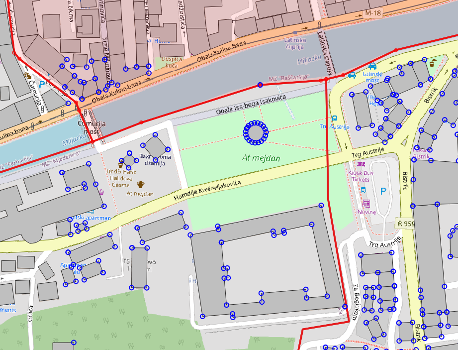
Route and Distance Analysis
Optimise logistics, map supply chains, estimate EV range distance and analyse business competition efficiently.
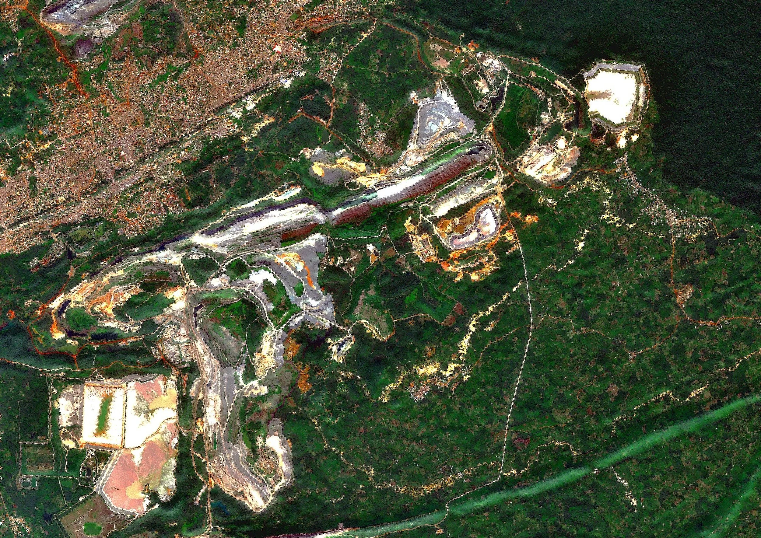

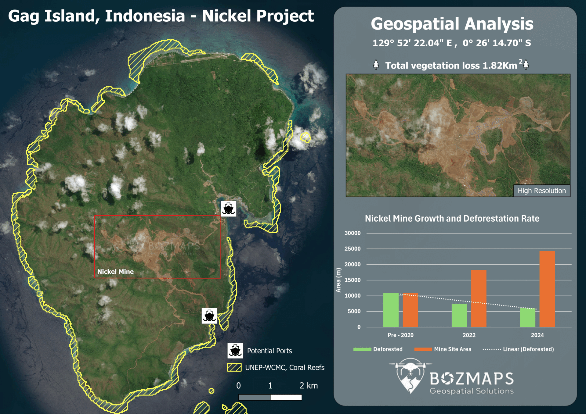
Mine Site Mapping
Track mining activity, monitor expansion, manage minerals, and assess deforestation.

Agriculture Mapping
Precise crop monitoring, soil analysis, and efficient resource management through spatial data insights.


Imagery Analysis
Analysis for infrastructure, disaster management, supply chain, and ESG monitoring.

Mapping and Digitising
Transform your data into Maps, graphs and dashboards, create unique insights and


Population and Geo-Data Analysis
Examine spatial relationships, trends, and distributions, aiding planning and resource allocation.
Our Process… Simple.
Quote
We recognize that every geospatial project is unique. That’s why we provide customized quotes based on your specific requirements. Our team will work closely with you to deliver a detailed and accurate quote within 24-48 hours of your request.
Planning and Data Requirements
Comprehensive planning is essential for successful outcomes. Our experts will assess your project needs, identify the data necessary for effective analysis, and develop a strategic plan that ensures precision and relevance in the data we capture.
Data Delivery
After thorough processing and analysis, we deliver the geospatial data in your preferred format. Our commitment is to ensure that all essential information is provided efficiently and on time, empowering you to make informed decisions.
GIS data capture
Advanced Digitising Techniques: Convert analog maps and imagery into high-quality digital formats.
Reliable Vector Datasets: Create precise vector data for a range of applications, such as urban planning, environmental management, and infrastructure.
Customised Solutions: Tailor data capture processes to meet the specific requirements of your project.
Data Cleaning and Validation
Error Detection and Correction: Identify and eliminate duplicates and inconsistencies to ensure data accuracy.
Geospatial Standards Compliance: Maintain adherence to industry standards, such as OGC, for reliable data quality.
Data Integrity Assurance: Implement robust mechanisms to detect errors and preserve data integrity.
Remote Sensing & Georeferencing
Advanced Data Acquisition and Analysis: Leverage cutting-edge technologies to collect and analyse remote sensing data effectively.
Accurate Georeferencing: Ensure precise spatial positioning for reliable mapping and analysis.
Customised Solutions: Tailor remote sensing workflows to meet the specific needs of your project.
GIS Training - Online and On-Site
1-on-1 Online Training and Career Guidance: Personalized sessions to help you master GIS skills and advance your career.
In-Person Group Training: Customized programs designed to meet the unique needs of your business.
Workshops and Seminars: Join interactive workshops and seminars, discussing geospatial workflows.
Location intelligence and spatial Analysis
Advanced GIS Techniques: Unlock the power of location intelligence and derive insights with Bozmaps.
Informed Decision-Making: Gain valuable insights for decision-making, resource allocation, and strategic planning.
Data-Driven Insights: Leverage spatial analysis to understand patterns, trends, and relationships.
Workflow and Database Design
Automate Geospatial Workflows: Develop efficient, automated workflows to reduce manual tasks.
Integrate with Existing Systems: Seamlessly connect your GIS solutions with other enterprise systems.
Data Migration and Standardization: Facilitate the transition from legacy systems, ensuring data consistency and compliance with industry standards.