
Which Official Maps Show Flood Risk for a Property?
The Environment Agency publishes the open flood maps for England. The Flood Map for Planning shows flood zones 1, 2 and 3. The national flood risk assessment, published from January 2025, gives the likelihood of flooding from rivers and the sea and from surface water. Separate maps show where water could go if a reservoir failed.
GOV.UK's Check your long term flood risk service shows these for a place in England, with groundwater where data is available and how climate change might raise the chance of flooding. Scotland, Wales and Northern Ireland have their own services.
| Source | What it shows | Use it to |
|---|---|---|
| Flood zones (Flood Map for Planning) | The chance of river or sea flooding each year, ignoring defences, as zones 1, 2 and 3 | See how planning policy treats the land |
| Rivers and sea likelihood (2025 assessment) | The chance of river or sea flooding each year, allowing for defences and their condition | Judge the chance of flooding today |
| Surface water likelihood (2025 assessment) | Where rain that cannot drain away or soak into the ground may flood | Spot flooding from heavy rain, which a flood zone does not show |
| Reservoir flood extents | Where water could go if a large reservoir failed, on a dry day and a wet day | See if the place is downstream of a dam |
| Groundwater susceptibility | Where the geology makes groundwater flooding possible | Flag a hazard, not a likelihood |
What Do Flood Zones 1, 2 and 3 Mean?
Flood zones band land by its chance of flooding from rivers or the sea in any year, ignoring flood defences. Zone 1 is under 0.1% (1 in 1,000). Zone 2 is 0.1% to 1% from rivers, or 0.1% to 0.5% from the sea. Zone 3 is 1% or more from rivers, or 0.5% or more from the sea.
- Zone 1, low probability: all land outside zones 2 and 3.
- Zone 2, medium probability: it also takes in land inside accepted records of past floods.
- Zone 3, high probability: it contains zone 3b, the functional floodplain where water has to flow or be stored in a flood. The Environment Agency does not have to map the outer edge of zone 3b, so check the council's strategic flood risk assessment for it.
Defences are left out unless a defence makes the area at risk larger. A home behind a well-kept embankment can therefore sit in zone 3. A second layer, Flood Zones plus climate change, shows how far zones 2 and 3 could spread over the next century, using the Met Office UKCP18 projections.
What Is the 2025 National Flood Risk Assessment?
The national flood risk assessment (NaFRA) is the Environment Agency's model of flood likelihood across England. New data for rivers and the sea, allowing for defences and their condition, and for surface water was published on 28 January 2025. Flood zones rebuilt from the new modelling reached the Flood Map for Planning on 25 March 2025.
| Band | Chance of flooding each year |
|---|---|
| High | 3.3% or more (1 in 30) |
| Medium | 1% up to 3.3% (1 in 100 to 1 in 30) |
| Low | 0.1% up to 1% (1 in 1,000 to 1 in 100) |
| Very low | Less than 0.1% (less than 1 in 1,000) |
In its December 2024 report the Environment Agency said 6.3 million properties in England are in areas at risk of flooding from rivers, the sea or surface water. Around 4.6 million of those are at risk from surface water, and the total could rise to around 8 million by the middle of the century.
Why Can a Home Be in Flood Zone 3 With a Low Likelihood?
Because the two maps answer different questions. The flood zone ignores defences, while the 2025 likelihood maps allow for them. A home behind a river wall can be in flood zone 3 yet have a low likelihood of flooding. Read both: the zone shows how planning treats the land, the likelihood shows the chance with defences working.
- Zone 3 with a high or medium likelihood: the place floods in the model even with defences working. Treat it as a serious risk.
- Zone 3 with a low or very low likelihood: defences are doing the work. Ask what protects the home and who maintains it.
- Zone 1 with surface water risk: rivers are not the issue, heavy rain is. The flood zone alone would miss it.
How Do You Check Reservoir Flood Risk?
Use the Environment Agency's reservoir flood maps. They show where water could go if a large raised reservoir failed, one that holds or could hold 25,000 cubic metres of water above ground level. Each has two cases: a dry day, with rivers at normal levels, and a wet day, with a river already in an extreme flood.
The maps give no likelihood. The Environment Agency describes each one as a credible worst case and says an actual flood is unlikely to be that large. Smaller reservoirs, and reservoirs built after the modelling programme began in October 2016, have no extent, so a blank map is not a guarantee.
What About Groundwater and Sewer Flooding?
Open data covers both poorly. The Environment Agency's flood zones leave out high groundwater and failing sewers or storm drains. GOV.UK's long term flood risk service shows groundwater only where data is available, and the national groundwater map from the British Geological Survey shows susceptibility, not the likelihood of a flood.
- The British Geological Survey's Groundwater Flooding Susceptibility map works at about 50 m and is meant for regional planning. It says it cannot be used on its own to show the risk at a site, and its terms ask for permission before the data is reproduced.
- Ask the seller whether the home has ever flooded from any source, including sewers and rising groundwater, and ask your conveyancer what the drainage and environmental searches cover.
What Is Flood Re and Does It Affect Buyers?
Flood Re is a flood reinsurance scheme, a joint initiative between government and the insurance industry, that helps households in flood risk areas get affordable home insurance. You do not apply to it: insurers pass eligible policies to it, so you buy cover from an insurer in the usual way. It is planned to stay in place until 2039.
Flood Re's eligibility rules say a home should be:
- built before 1 January 2009 (a home rebuilt after demolition still counts);
- in a domestic Council Tax band, A to H or the equivalent;
- used for private, residential purposes, with the policy held by one or more individuals;
- a single home or a building of two or three homes: blocks of more than three flats are excluded.
Company-owned homes and bed and breakfasts paying business rates are not expected to qualify; buy-to-let homes can if they meet the rest. For a buyer, a home built in 2009 or later in a flood risk area has no Flood Re support, so get an insurance quote before you exchange contracts.
When Do You Need a Professional Flood Risk Assessment?
For a planning application, the 2026 National Planning Policy Framework asks for a site-specific flood risk assessment for all development in flood zones 2, 3a and 3b. In zone 1 it is needed for sites of one hectare or more, land with critical drainage problems, and land shown at risk of flooding from any source, now or in future.
The Environment Agency's guidance says you will usually need to pay a flood risk specialist to carry one out, although a simple low-risk project such as a house extension may be something you can do yourself.
For a purchase there is no legal trigger, but specialist advice or a surveyor's view is worth getting when:
- the likelihood from rivers, the sea or surface water is medium or high;
- the home is in flood zone 3 with a low likelihood, because its safety depends on defences;
- there is any sign or record of past flooding, including from groundwater or sewers;
- you plan to extend, convert or redevelop the property.
How Does the Bozmaps Property Risk Check Show Flood Risk?
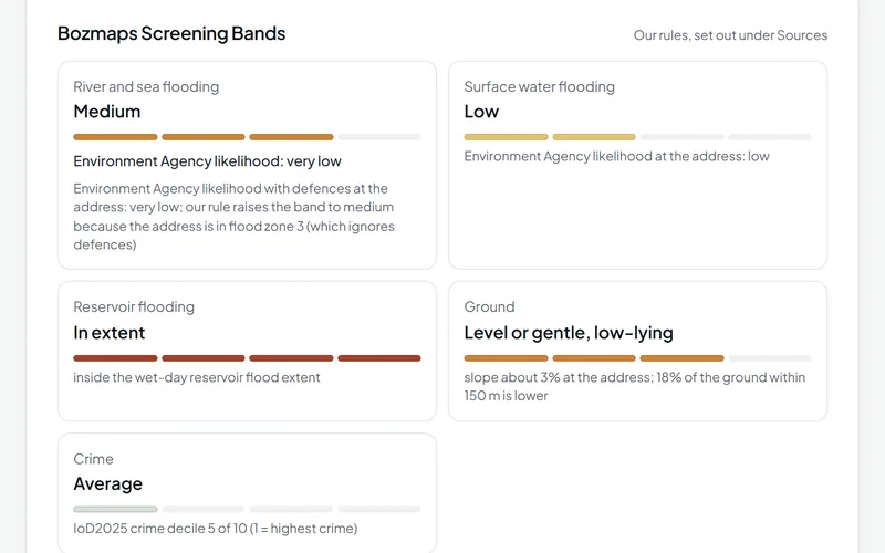
The Bozmaps property risk check reads the Environment Agency's flood zones, the 2025 likelihood maps for rivers, the sea and surface water, and both reservoir flood extents for one address in England, live from the public services. It dates every source and shows the Environment Agency's own figure beside a Bozmaps screening band.
- Rivers and sea: the band starts from the Environment Agency's likelihood with defences at the address and is raised to medium when the address is in flood zone 3 and the likelihood is lower. The card then says so and shows the official figure.
- Surface water: the likelihood at the address and within 20 m.
- Reservoirs: whether the address is inside the wet-day or dry-day extent.
- Ground: slope, and whether the address sits low against the ground around it, from Environment Agency LiDAR.
- Not covered: groundwater, sewer flooding and subsidence. A postcode is placed at its centre, which can be tens of metres from the building.
Read how it works on the property risk check page, and see every dataset, publisher and licence on Sources.
Sources
- Flood Zones: product description, Environment Agency, 30 June 2026
- Flood Map for Planning: Flood Zones (dataset), Environment Agency, 22 October 2026
- New national flood and coastal erosion risk information, Environment Agency, 5 August 2026
- Risk of Flooding from Rivers and Sea (dataset), Environment Agency, 28 January 2025
- Risk of Flooding from Surface Water (dataset), Environment Agency, 28 January 2025
- Environment Agency publishes major update to national flood and coastal erosion risk assessment, Environment Agency, 17 December 2024
- Check the long term flood risk for an area in England, GOV.UK (Environment Agency)
- Reservoir flood maps: when and how to use them, Environment Agency, 9 December 2025
- Reservoir Flood Extents: Dry Day (National) (dataset), Environment Agency, 18 September 2026
- Reservoirs: owner and operator requirements, Environment Agency, 23 February 2024
- Groundwater Flooding Susceptibility (dataset), British Geological Survey, 6 November 2026
- Flood Re, GOV.UK
- Eligibility: frequently asked questions, Flood Re
- Our future, Flood Re
- National Planning Policy Framework, chapter 18: managing flood risk and coastal change (F1 to F9), Ministry of Housing, Communities and Local Government, 17 August 2026
- Flood risk assessments: applying for planning permission, Environment Agency, 28 May 2026
This guide is general information, not professional advice. Check anything you rely on with the source, and with a surveyor, solicitor or consultant where it matters.