
Property Risk Check for One Address
The property risk check screens one address in England against the Environment Agency's flood maps and LiDAR ground heights, police.uk crime, the English Indices of Deprivation 2025 and HM Land Registry sales. It gives a screening band for each peril, shows the Environment Agency's own figure beside ours where they differ, and dates every source.
What You Give It
- A postcode or a street address. A postcode is placed at its centre point.
- For the exact building, click it on the property finder map: the same check runs for that spot.
What You Get
Five Screening Bands
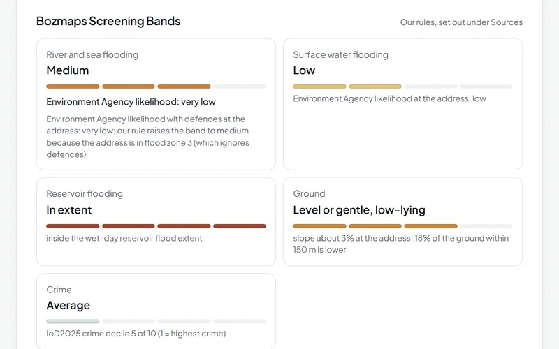
River and sea flooding, surface water flooding, reservoir flooding, ground and crime, each with a one-line reason.
Flooding in Detail
The flood zone, the Environment Agency's likelihood with defences at the address and within 20 m, surface water likelihood, the distance to flood zone 3 when the address is outside it, and whether it is inside the wet-day or dry-day reservoir flood extent.
Ground and Slope
Height above sea level and slope at the address from Environment Agency LiDAR, how much of the ground within 150 m is lower, and the height against the middle of its surroundings.
Crime, Deprivation and Sales
Crimes recorded within 250 m over the latest 12 months, by type; the neighbourhood's deprivation decile and domains; and the homes sold at the postcode over 24 months with their median price, beside the median for the postcode sector.
Nearby Places and Designations
The nearest rail station, tram or metro stop and primary and secondary school, and whether the spot is in a conservation area, Article 4 direction area, green belt, tree preservation order area, National Park or National Landscape, or within 25 m of a listed building.
A Plain-English Summary With Sources
A short summary written from the figures, and every source with its publisher, licence and the date it was read.
How It Works
The check reads each public service for the point you give, then applies a short set of written rules to turn the figures into screening bands. The rules travel with every result, so anyone can see why a band was given.
How the Bands Are Set
| Peril | Rule |
|---|---|
| River and sea flooding | Starts from the Environment Agency's likelihood with defences at the address (high, medium, low or very low). Raised to medium if the address is in flood zone 3, which ignores defences, and the likelihood is lower. The Environment Agency's own figure is then shown beside the band. |
| Surface water flooding | The Environment Agency's likelihood at the address. Outside its high, medium and low areas the band is very low, as on GOV.UK's Check your long term flood risk service. |
| Reservoir flooding | In extent or not, for the wet-day and dry-day reservoir flood extents. A reservoir failing is an unlikely event. |
| Ground | Slope at the address: under 5% level or gentle, 5 to 10% moderate, 10 to 20% steep, over 20% very steep. Low-lying when less than 20% of the ground within 150 m is lower than the address. |
| Crime | The neighbourhood's crime decile in the English Indices of Deprivation 2025: 1 to 2 high, 3 to 4 above average, 5 to 6 average, 7 to 10 low. Police counts within 250 m are shown alongside. |
What the Environment Agency's Likelihood Bands Mean
- High: more than a 3.3% chance of a flood each year.
- Medium: between 1% and 3.3% each year.
- Low: between 0.1% and 1% each year.
- Very low: less than a 0.1% chance each year.
When Data Is Missing
'Not shown at risk' for rivers and the sea means the address is outside every area in the Environment Agency's likelihood data; it is not a guarantee. When data.police.uk is missing months for the police force, the check names the months, counts only what is published and gives no crime band or yearly figure. On 9 November 2026, Greater Manchester Police had no street-level crime on data.police.uk at all. When a service does not answer, that part says it was not checked instead of showing a clean result.
SW1A 2AA, London
A check on 9 November 2026 gave river and sea flooding a medium band: the Environment Agency's likelihood with defences was very low, but the address is in flood zone 3, so our rule raised it. Surface water was low and the address is inside the wet-day reservoir flood extent. The ground is level or gentle, about 3%, and low-lying, with only 18% of the ground within 150 m lower. The crime decile was 5 of 10, average.
Run this check againThe Data Behind It
Flood Map for Planning (Rivers and Sea), flood zones 2 and 3
Environment Agency · Open Government Licence v3.0
Risk of flooding from rivers and sea, and from surface water (NaFRA2)
Environment Agency · Open Government Licence v3.0
Reservoir flood extents (wet day and dry day)
Environment Agency · Open Government Licence v3.0
Environment Agency · Open Government Licence v3.0
data.police.uk (Home Office) · Open Government Licence v3.0
English Indices of Deprivation 2025
Ministry of Housing, Communities and Local Government · Open Government Licence v3.0
LSOA boundaries (December 2021)
Office for National Statistics · Open Government Licence v3.0
HM Land Registry · Open Government Licence v3.0
Postcodes (ONS Postcode Directory via postcodes.io)
Office for National Statistics, Ordnance Survey, Royal Mail · Open Government Licence v3.0
Public transport stops (NaPTAN)
Department for Transport · Open Government Licence v3.0
Schools (Get Information about Schools)
Department for Education · Open Government Licence v3.0
planning.data.gov.uk (MHCLG) · Open Government Licence v3.0
| Data | Published by | Licence |
|---|---|---|
| Flood Map for Planning (Rivers and Sea), flood zones 2 and 3 | Environment Agency | Open Government Licence v3.0 |
| Risk of flooding from rivers and sea, and from surface water (NaFRA2) | Environment Agency | Open Government Licence v3.0 |
| Reservoir flood extents (wet day and dry day) | Environment Agency | Open Government Licence v3.0 |
| LIDAR Composite DTM, 2 m | Environment Agency | Open Government Licence v3.0 |
| Street-level crime | data.police.uk (Home Office) | Open Government Licence v3.0 |
| English Indices of Deprivation 2025 | Ministry of Housing, Communities and Local Government | Open Government Licence v3.0 |
| LSOA boundaries (December 2021) | Office for National Statistics | Open Government Licence v3.0 |
| Price Paid Data | HM Land Registry | Open Government Licence v3.0 |
| Postcodes (ONS Postcode Directory via postcodes.io) | Office for National Statistics, Ordnance Survey, Royal Mail | Open Government Licence v3.0 |
| Public transport stops (NaPTAN) | Department for Transport | Open Government Licence v3.0 |
| Schools (Get Information about Schools) | Department for Education | Open Government Licence v3.0 |
| Planning designations | planning.data.gov.uk (MHCLG) | Open Government Licence v3.0 |
Every dataset and its credit line is on data sources and licences.
What It Can't Tell You
- England only for flooding, ground, deprivation and designations; crime and sales also cover Wales. Scotland and Northern Ireland are not covered.
- Groundwater, sewer flooding and subsidence, including shrink-swell clay and mining, are not covered.
- A postcode is placed at its centre, which can be tens of metres from the building.
- police.uk moves each crime to a nearby anonymous map point, so counts within 250 m are close, not exact.
- Not an underwriting model: there is no claims history, building construction or sum insured.
- Street addresses are looked up in the EPC register; where that service is not connected, search by postcode.
The tools are in preview: built and tested, not yet signed off as validated. They screen a place from public data and don't replace a survey or professional advice.
Questions
Something else? Ask us.
Why is our band medium when the Environment Agency says very low?
Because the address is in flood zone 3. Flood zone 3 ignores defences, so our rule raises the river and sea band to medium when the likelihood with defences is lower. The result shows the Environment Agency's own figure beside our band, so you see both and can judge the defences yourself.
Is this the same as GOV.UK's long term flood risk service?
It reads the Environment Agency's 2025 national likelihood data for rivers, the sea and surface water, and follows GOV.UK's Check your long term flood risk service in calling surface water 'very low' outside the mapped areas. It adds flood zones, reservoirs, ground height, crime, deprivation and sales, and our screening bands.
Why is there no crime band for some addresses?
Because the police force has months missing on data.police.uk. An incomplete count gives no fair yearly figure, so the check names the missing months, shows the counts it has and gives no band, yearly figure or crime decile.
Can I check a property in Wales?
Partly. Crime and sales work in Wales. The flood maps, LiDAR heights and deprivation index come from English publishers, so those parts say they are not covered. Natural Resources Wales publishes the Welsh flood map.
Can I check a list of addresses?
Yes, with portfolio screening: up to 200 addresses from one CSV file, with a lighter version of the same flood, crime and deprivation checks.
Is the result advice?
No. It is information only, not insurance, lending, financial, legal or surveying advice. It tells you what national open data says about a point, so you know what to ask a surveyor, insurer or lender.
Read Next
Who Uses It
- InsuranceScreen one address or up to 200 for flood zones, flood likelihood, reservoirs, ground and crime, from Environment Agency, police.uk and other open data.
- Finance and LendingCheck sale prices, flood exposure, crime and deprivation behind a loan, for one property or up to 200, from HM Land Registry and Environment Agency data.
- PropertyFlood exposure, planning designations, crime, deprivation and recent sales for any address in England, from official open data. For agents and investors.
Guides
- How to Check Flood Risk for a Property in EnglandFlood zones, 2025 national flood risk data, reservoir maps, groundwater and Flood Re: what each shows for a home in England and when to get a specialist.
- Crime, Deprivation and House Prices Around a PostcodeHow to read police.uk crime data, the English Indices of Deprivation 2025, Land Registry Price Paid Data and Census 2021 for the area around a postcode.
Related Tools
- Portfolio screeningUpload a CSV of up to 200 addresses and see which are most exposed to flooding, reservoirs and crime, on a sortable table, a map and a CSV to download.
- Property finderSearch homes sold and commercial premises in England and Wales, filter by flood zone, crime and deprivation, and open a risk check on any address.
- Flood and terrainHow much of a site in England is in each flood zone and likelihood band, which reservoirs could reach it, and its height, slope and overland flow.
Want These Checks Run for Your Sites?
Send us the addresses or the site outlines. We run the full checks on the Bozmaps engine, and a person reviews every report before it reaches you.