
Store Catchment Analysis for Retailers
See who lives within a walk or a drive of a store, what their councils' households have to spend and how many shops of the same kind compete for them. The public site shows real example runs; we run new catchments for you on request.
The Questions It Answers
How Many People Live Within Reach?
Walking and driving catchments measured along the OpenStreetMap street network towards the store, with the Census 2021 residents and households inside each one.
What Do They Have to Spend?
Each council's gross disposable household income per head (ONS, 2024), weighted by where the catchment's residents live, with the share of households without a car and of residents in managerial or professional jobs.
How Many Shops Compete for Them?
Shops of the same kind mapped in OpenStreetMap, counted inside each catchment, with the nearest one and its straight-line distance. 28 shop types are covered, from supermarkets and bakeries to pharmacies, cafes and pubs.
What You Can Do
How It Works
1.Name the Store and the Shop Type
A postcode or a point on the map, and which kind of shop competes with it. Send it through the contact form.
2.We Draw the Catchments
Walking and driving areas, for example 5, 10 and 15 minutes on foot and 5 and 10 minutes by car, each with its residents, households, income and competing shops.
3.Read the Report
A map for each way of travelling, a table for each catchment, the method, the limits and the sources, reviewed by a person before it is sent.
A Supermarket in Radford, Nottingham
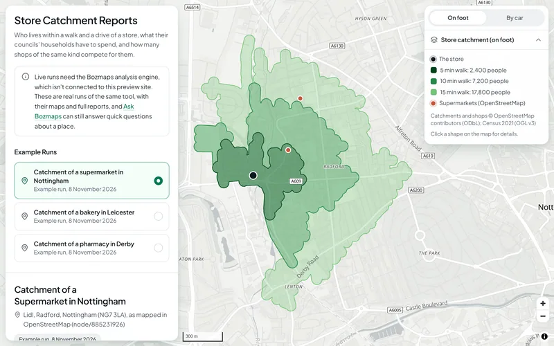
In an example run on 8 November 2026, about 2,400 people lived within a 5-minute walk of the store and 17,800 within 15 minutes, and about 524,000 within a 10-minute drive (Census 2021). In that drive area 31% of households had no car, the councils' disposable household income averaged £20,432 a head (79% of the UK average, ONS 2024), and OpenStreetMap showed 83 other supermarkets.
See this exampleThe Data Behind It
Office for National Statistics (via Nomis) · Open Government Licence v3.0
Output area boundaries and lookups
Office for National Statistics · Open Government Licence v3.0
Gross disposable household income by local authority, 2024
Office for National Statistics · Open Government Licence v3.0
OpenStreetMap contributors · Open Database Licence 1.0
| Data | Published by | Licence |
|---|---|---|
| Census 2021 tables | Office for National Statistics (via Nomis) | Open Government Licence v3.0 |
| Output area boundaries and lookups | Office for National Statistics | Open Government Licence v3.0 |
| Gross disposable household income by local authority, 2024 | Office for National Statistics | Open Government Licence v3.0 |
| Street networks and shops | OpenStreetMap contributors | Open Database Licence 1.0 |
Every dataset and its credit line is on data sources and licences.
What It Can't Tell You
- Residents only (Census 2021): workers, students away from home, visitors and passing trade are not counted.
- Spending power is each council's average disposable income per head (ONS, 2024, provisional), weighted by where the catchment's residents live; it is not measured for the catchment, and it is income, not spending in shops.
- Competing shops come from OpenStreetMap, which volunteers map: some shops are missing, some have closed, and the shop type is as tagged.
- Drive times are free-flow unless a speed factor is set; parking and congestion are not included.
- The street network is only as complete as OpenStreetMap; public transport is not included.
- The public site shows example runs only; a catchment for a new store runs on the Bozmaps engine, on request.
The tools are in preview: built and tested, not yet signed off as validated. They screen a place from public data and don't replace a survey or professional advice.
Questions
Something else? Ask us.
Can I run a catchment for my own store here?
Not on the public site. It shows real example runs for a supermarket in Nottingham, a bakery in Leicester and a pharmacy in Derby, each with its map and full report. New catchments need the Bozmaps engine, so request a site report and we run it for you.
Is the income figure what people in the catchment spend?
No. It is each council's average gross disposable household income per head (ONS, 2024, provisional), weighted by where the catchment's residents live. It is income, not spending in shops, and it is not measured for the catchment itself.
Are workers and visitors counted?
No. Catchments count Census 2021 residents only, so workers, students away from home, visitors and passing trade are left out. For a shop that lives on footfall from offices or a station, treat the figures as a floor.
How complete is the list of competing shops?
As complete as OpenStreetMap, which volunteers map: some shops are missing, some have closed, and each shop's type is as it was tagged. The counts are a guide to competition, not a full list of it.
Do drive times allow for traffic?
By default they assume free-flowing traffic at the speed limit. A speed factor can slow every road for busy times, about 0.6 for example, but parking and congestion are not modelled.
Read Next
Tools
- Store catchment reportWho lives within a walk and a drive of a store, what their councils' households have to spend, and how many shops of the same kind compete for them.
- Who can reach this placeHow many people live within a walk, a bike ride or a drive of a site in England or Wales, from travel-time areas drawn on the real road and path network.
- Area profileCensus 2021 people and homes, deprivation, house prices and recorded crime around a site in England or Wales, compared with the council and the country.
- Property finderSearch homes sold and commercial premises in England and Wales, filter by flood zone, crime and deprivation, and open a risk check on any address.
Guides
- How to Size a Store Catchment With Open DataWalk and drive time catchments, Census 2021 residents and cars, ONS household income and rival shops from OpenStreetMap, with three real example runs.
- Crime, Deprivation and House Prices Around a PostcodeHow to read police.uk crime data, the English Indices of Deprivation 2025, Land Registry Price Paid Data and Census 2021 for the area around a postcode.
Want These Checks Run for Your Sites?
Send us the addresses or the site outlines. We run the full checks on the Bozmaps engine, and a person reviews every report before it reaches you.