
Site Checks for Planning and Development
Five checks for a site in England: the designations on and around it, who lives nearby, who can reach it, where the best land is and how exposed it is to flooding. They run on the Bozmaps engine, so we run them for you and a person reviews every report.
The Questions It Answers
What Designations Affect the Site?
The planning constraints check tests 23 national datasets on and near the site, from conservation areas, listed buildings, Article 4 directions and tree preservation orders to green belt, nature sites and flood zones. Where a council has not published a dataset to the national platform, it says so instead of reporting none found.
Who Lives Here, and Who Can Get Here?
The area profile gives Census 2021 people and homes, deprivation, sale prices and recorded crime, compared with the council. Who can reach this place counts the residents within a walk, a cycle ride or a drive along the real street network.
Where Is the Best Land, and Will It Flood?
The site finder rules out protected and flood-prone land, scores the rest on what matters to you and tests how firm the ranking is. Flood and terrain measures how much of a site falls in each flood zone and likelihood band, its height and slope, and where rainwater runs across it.
What You Can Do
How It Works
1.Tell Us the Site
A postcode, a grid reference, an outline drawn on a map or a plan, and the question you need answered. Send it through the contact form.
2.We Run the Checks
The checks run on the Bozmaps engine against national open data. Each run keeps a record of its inputs, settings, the date it ran and the software versions, so it can be traced and run again.
3.You Get a Reviewed Report
The answer in plain English, maps, the figures, the method, the limits and every source, checked by a person before it is sent.
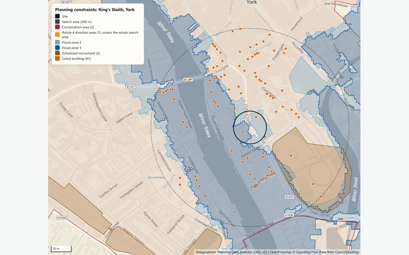
Planning Constraints at King's Staith, York
In an example run on 2 November 2026 for a 40 m circle at King's Staith, York, the site was inside a conservation area and an Article 4 direction area, and overlapped 2 listed buildings and flood zones 2 and 3. Within 200 m were 2 scheduled monuments, the nearest 30 m away, and 89 more listed buildings. York had not published tree preservation order data to the national platform, so the report said to check the council's own records.
How the planning constraints check worksThe Data Behind It
Planning Data platform (MHCLG) · Open Government Licence v3.0
Flood Map for Planning (flood zones 2 and 3)
Environment Agency · Open Government Licence v3.0
Risk of flooding from rivers and the sea, and from surface water (2025 national assessment)
Environment Agency · Open Government Licence v3.0
Environment Agency · Open Government Licence v3.0
LiDAR Composite DTM, 1 m
Environment Agency · Open Government Licence v3.0
Office for National Statistics (via Nomis) · Open Government Licence v3.0
English Indices of Deprivation 2025
Ministry of Housing, Communities and Local Government · Open Government Licence v3.0
HM Land Registry · Open Government Licence v3.0
police.uk (Home Office) · Open Government Licence v3.0
Public transport stops (NaPTAN)
Department for Transport · Open Government Licence v3.0
Schools (Get Information about Schools)
Department for Education · Open Government Licence v3.0
OpenStreetMap contributors · Open Database Licence 1.0
| Data | Published by | Licence |
|---|---|---|
| Planning designations | Planning Data platform (MHCLG) | Open Government Licence v3.0 |
| Flood Map for Planning (flood zones 2 and 3) | Environment Agency | Open Government Licence v3.0 |
| Risk of flooding from rivers and the sea, and from surface water (2025 national assessment) | Environment Agency | Open Government Licence v3.0 |
| Reservoir flood extents | Environment Agency | Open Government Licence v3.0 |
| LiDAR Composite DTM, 1 m | Environment Agency | Open Government Licence v3.0 |
| Census 2021 | Office for National Statistics (via Nomis) | Open Government Licence v3.0 |
| English Indices of Deprivation 2025 | Ministry of Housing, Communities and Local Government | Open Government Licence v3.0 |
| Price Paid Data | HM Land Registry | Open Government Licence v3.0 |
| Street-level crime | police.uk (Home Office) | Open Government Licence v3.0 |
| Public transport stops (NaPTAN) | Department for Transport | Open Government Licence v3.0 |
| Schools (Get Information about Schools) | Department for Education | Open Government Licence v3.0 |
| Street networks | OpenStreetMap contributors | Open Database Licence 1.0 |
Every dataset and its credit line is on data sources and licences.
What It Can't Tell You
- Screening checks, not a formal planning search, a local authority search, a site-specific flood risk assessment or legal advice.
- Designations are as published on the national platform on the day of the run; councils may hold more, and some have not published every dataset.
- A postcode or a point is not the legal boundary of a site: use the registered title outline for decisions.
- Drive times assume free-flowing traffic at the speed limit, and public transport is not included.
- Water flow runs over bare earth: buildings, walls, kerbs, drains and culverts change real flow paths. Groundwater and sewer flooding are not covered.
- England only for designations, flooding and the site finder; the area profile and travel times also cover Wales, without deprivation.
The tools are in preview: built and tested, not yet signed off as validated. They screen a place from public data and don't replace a survey or professional advice.
Questions
Something else? Ask us.
Can I run these checks myself on the website?
Not on the public site. The five checks need the Bozmaps analysis engine, which this site is not connected to, so we run them for you: request a site report.
The property risk check does run live, and covers the main designations, flooding and ground for one address.
Does 'none found' mean there is no constraint?
Only where the council has published that dataset. For council-published datasets with no records near the site, the check tests whether the council has any records at all, and if it has none it says the data has not been published rather than reporting none found. In those cases, check the council's own records.
Will I need a flood risk assessment?
The flood and terrain report says when one is normally needed for development: a site in flood zone 2 or 3, a site of 1 hectare or more, or a site with any land at medium or high risk of surface water flooding. It is a screening and does not replace a site-specific flood risk assessment.
How does the site finder rank sites?
It lays a grid of 100 m cells over the search area, rules out cells inside protected land and flood zone 3, and scores the rest from 0 to 1 against weighted criteria such as distance to rail stations, bus stops and schools. Candidate sites grow from the best cells.
It then varies each weight by up to 20% over 500 runs and reports how often each site stays in the top three, so you can see how firm the ranking is.
What is in a site report?
The checks that fit your question, each with the answer in plain English, maps, tables of figures, the method, the limits and every source with its publisher and licence. A person reviews every report before it is sent.
How much does a site report cost?
Prices are not published while site reports run as a pilot. Tell us the sites and what you need to know through the contact form and we reply with what we can do.
Read Next
Tools
- Planning constraintsSee which of 23 planning and environmental designations cover a site in England or lie near it, and where the council has not published its data.
- Area profileCensus 2021 people and homes, deprivation, house prices and recorded crime around a site in England or Wales, compared with the council and the country.
- Who can reach this placeHow many people live within a walk, a bike ride or a drive of a site in England or Wales, from travel-time areas drawn on the real road and path network.
- Site finderRule out protected and flood-prone land, score the rest on what matters to you, rank the best sites in an area of England and test how firm the ranking is.
- Flood and terrainHow much of a site in England is in each flood zone and likelihood band, which reservoirs could reach it, and its height, slope and overland flow.
- Property risk checkCheck one address in England for flood zone, flood likelihood, reservoirs, ground slope, crime, deprivation and recent sales, with every source dated.
Guides
- Planning Constraints to Check Before You Buy Land or a BuildingListed buildings, conservation areas, Article 4, tree orders, green belt, flood zones and nature sites: what each means in England and how to check for it.
- How to Check Flood Risk for a Property in EnglandFlood zones, 2025 national flood risk data, reservoir maps, groundwater and Flood Re: what each shows for a home in England and when to get a specialist.
- Crime, Deprivation and House Prices Around a PostcodeHow to read police.uk crime data, the English Indices of Deprivation 2025, Land Registry Price Paid Data and Census 2021 for the area around a postcode.
Want These Checks Run for Your Sites?
Send us the addresses or the site outlines. We run the full checks on the Bozmaps engine, and a person reviews every report before it reaches you.