
Planning Constraints Check for a Site
The planning constraints check lists the designations that cover a site in England or lie within a set distance of it: conservation areas, listed buildings, Article 4 directions, tree preservation orders, green belt, flood zones and nature sites, 23 datasets in all. Where a council has not published a dataset, it says so instead of reporting none found.
What You Give It
- The site: a postcode with a size, an outline drawn on a map, or a file (GeoPackage, GeoJSON, KML, FlatGeobuf or a zipped shapefile).
- How far around the site to look: the site only, or 50 m, 100 m, 250 m, 500 m or 1 km. The usual distance is 250 m. Everything on the site is always listed.
What You Get
A Plain-English Answer
What the site is on or overlaps, what lies within the search distance and how near the closest one is, and which datasets the council has not published.
Every Dataset, Marked
All 23 datasets, each marked found, none found or not published by the council, with the count on the site, the count nearby, the nearest distance and named examples, such as a listed building with its grade.
A Map of the Designations
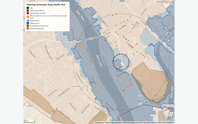
The site, the search area and every designation found, coloured by type.
A Report and the Data
A report with the method, limits and every source's attribution, and the designations found as a GeoPackage file for your own GIS.
How It Works
The check asks the national Planning Data platform (planning.data.gov.uk, run by MHCLG) for every designation that touches the site or the search area. Flood zones come from the Environment Agency's current Flood Map for Planning. A designation counts as on the site if it touches the site outline; distances are straight lines measured in British National Grid.
The 23 Datasets
| Group | Datasets |
|---|---|
| Heritage | Conservation areas, listed buildings, listed building outlines, scheduled monuments, registered parks and gardens, registered battlefields, World Heritage Sites and their buffer zones |
| Planning policy | Article 4 direction areas, green belt |
| Trees | Tree preservation order areas, protected trees |
| Flood | Flood zones 2 and 3 |
| Ecology | Sites of Special Scientific Interest, Special Areas of Conservation, Special Protection Areas, Ramsar sites, National Nature Reserves, Local Nature Reserves, ancient woodland |
| Landscape | National Landscapes (AONB), National Parks, heritage coast |
None Found or Not Published
Six datasets are published council by council: conservation areas, listed building outlines, Article 4 directions, green belt, tree preservation order areas and protected trees. When one of these finds nothing near the site, the check asks whether the council has published that dataset at all. If it has not, the result says not published by the council, never none found, so a gap in the national data does not read as a clean site.
If the platform does not answer when the check asks which council covers the site, the check stops. Without the council it cannot tell none found from not published, so it gives no answer rather than a cleaner one than the data supports.
King's Staith, York
In an example run on 2 November 2026 on a 40 m circle at King's Staith, York, searched to 200 m, the site overlapped the Central Historic Core Conservation Area, an Article 4 direction area (HMO), flood zones 2 and 3 and 2 listed buildings. Within 200 m were 89 more listed buildings, 2 scheduled monuments (the nearest 30 m away) and 1 more conservation area. York had not published tree preservation order data to the national platform, so the report said to check the council's own records.
The Data Behind It
planning.data.gov.uk (MHCLG) · Open Government Licence v3.0
Listed buildings, scheduled monuments, registered parks, gardens and battlefields, World Heritage Sites (via Planning Data)
Historic England · Open Government Licence v3.0
Nature and landscape designations (via Planning Data)
Natural England · Open Government Licence v3.0
Conservation areas, Article 4 directions, green belt and tree preservation orders (via Planning Data)
Local planning authorities · Open Government Licence v3.0
Flood Map for Planning (Rivers and Sea), flood zones 2 and 3
Environment Agency · Open Government Licence v3.0
| Data | Published by | Licence |
|---|---|---|
| Planning designations | planning.data.gov.uk (MHCLG) | Open Government Licence v3.0 |
| Listed buildings, scheduled monuments, registered parks, gardens and battlefields, World Heritage Sites (via Planning Data) | Historic England | Open Government Licence v3.0 |
| Nature and landscape designations (via Planning Data) | Natural England | Open Government Licence v3.0 |
| Conservation areas, Article 4 directions, green belt and tree preservation orders (via Planning Data) | Local planning authorities | Open Government Licence v3.0 |
| Flood Map for Planning (Rivers and Sea), flood zones 2 and 3 | Environment Agency | Open Government Licence v3.0 |
Every dataset and its credit line is on data sources and licences.
What It Can't Tell You
- A screening check, not a formal planning search, local authority search or legal advice.
- England only. Records are as published on the national platform on the day of the check; councils may hold more.
- Planning applications, planning history and local plan allocations are not part of the check.
- Flood zones ignore defences and are not a site-specific flood risk assessment.
- Listed buildings are mapped as points or outlines; the legal extent can include structures within the curtilage.
- A postcode site is a circle, not the legal boundary: use the registered title outline for decisions.
The tools are in preview: built and tested, not yet signed off as validated. They screen a place from public data and don't replace a survey or professional advice.
Questions
Something else? Ask us.
What does 'not published by the council' mean?
The council has not sent that dataset to the national Planning Data platform, so the check cannot say whether there is one near the site. Ask the council or look at its own map before treating the site as clear of that designation.
Is this a local authority search?
No. It is a screening from national open data, useful before an offer, a bid or a design brief. A local authority search comes from the council itself and covers matters this check does not, such as planning history.
How far around the site does it look?
250 m is the usual distance, and anything from the site only up to 1 km can be set. Every designation on the site is listed whatever the distance.
Does it cover Wales or Scotland?
No. The Planning Data platform and the Environment Agency's flood zones cover England only.
Can I run this check on the website?
Not on the public site. The check runs on the Bozmaps analysis engine, which the public site is not connected to, so we run it for you. Send us the site as a postcode, an outline or a file, with the search distance you want, and a person reviews the report before it is sent.
Read Next
Who Uses It
- Planning and DevelopmentPlanning constraints, area profile, travel-time reach, site finder and flood and terrain checks for a site in England, run for you and checked by a person.
- PropertyFlood exposure, planning designations, crime, deprivation and recent sales for any address in England, from official open data. For agents and investors.
- Finance and LendingCheck sale prices, flood exposure, crime and deprivation behind a loan, for one property or up to 200, from HM Land Registry and Environment Agency data.
Related Tools
- Flood and terrainHow much of a site in England is in each flood zone and likelihood band, which reservoirs could reach it, and its height, slope and overland flow.
- Site finderRule out protected and flood-prone land, score the rest on what matters to you, rank the best sites in an area of England and test how firm the ranking is.
- Area profileCensus 2021 people and homes, deprivation, house prices and recorded crime around a site in England or Wales, compared with the council and the country.
Want These Checks Run for Your Sites?
Send us the addresses or the site outlines. We run the full checks on the Bozmaps engine, and a person reviews every report before it reaches you.