
Site Finder: The Best Sites in an Area
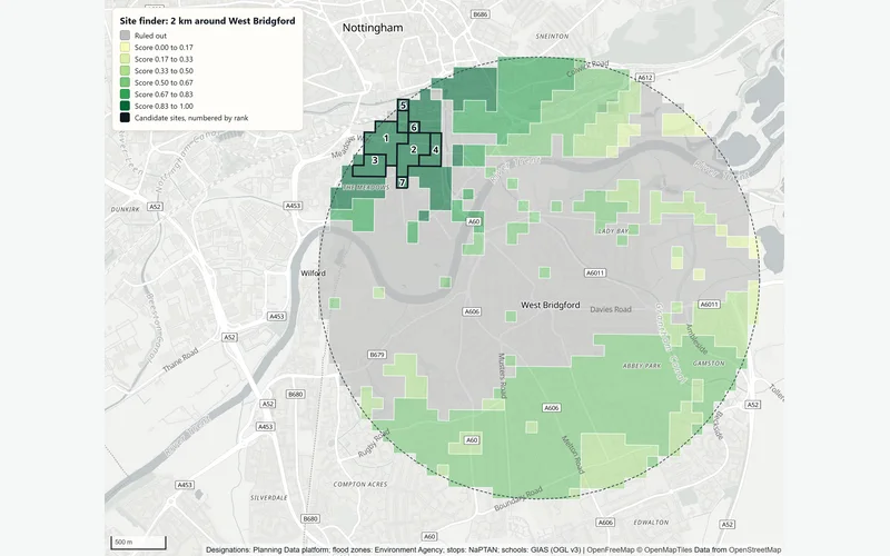
The site finder searches an area of England for the highest-scoring places for a use you describe. It rules out protected and flood-prone land, scores the rest on weighted criteria such as distance to stations, bus stops and schools, joins the best cells into candidate sites, ranks them, and tests how well the ranking holds when the weights change.
What You Give It
- The search area: a site with a distance around it (1, 2, 3 or 5 km), or an outline of 25 ha or more searched as drawn.
- What matters, and how much: being near a rail station, a tram or metro stop, a bus stop, a primary school or a secondary school, each not used, a little, quite or very important; and deprivation or population, preferring higher or lower.
- Which flood land to rule out: flood zone 3 (the usual choice), flood zones 2 and 3, or none.
- How big a candidate site can be: the smallest from 0.25 to 5 ha and the largest from 2 to 50 ha. 1 ha and 10 ha are the usual sizes.
What You Get
Ranked Candidate Sites
Each with its size, a score from 0 to 1, a grid reference, and the distance from its centre to the nearest of each thing that matters, named.
How Firm the Ranking Is
For each site, the share of 500 test runs in which it stays in the top 3 and the range of ranks it takes when the weights change.
What Was Ruled Out
How many cells each designation and flood zone removed from the search.
A Score Map and a Report
Every cell shaded by score, ruled-out land in grey and the candidate sites numbered by rank, with the criteria, weights, method and limits.
How It Works
The site finder is multi-criteria evaluation, written down so the same inputs always give the same answer.
- Cover the search area with a grid of 100 m cells in British National Grid.
- Rule out every cell whose centre is inside a protected designation or the flood zones you chose. Always ruled out: Sites of Special Scientific Interest, Special Areas of Conservation, Special Protection Areas, Ramsar sites, National Nature Reserves, ancient woodland, scheduled monuments, registered parks and gardens, registered battlefields and World Heritage Sites. An exclusion is never applied from a partial download.
- Score each remaining cell from 0 to 1 on each criterion. For a distance, the score falls in a straight line from 1 at the full-score distance to 0 at the zero-score distance (table below). Deprivation deciles and population densities are scaled from 0 to 1.
- Weight each score by its importance and add them up (a weighted linear combination). Weights can also come from a pairwise comparison matrix (the analytic hierarchy process), with its consistency ratio reported.
- Take the best 5% of cells and grow candidate sites from the best cell outwards through touching cells, up to the largest size; drop sites under the smallest size; rank the sites by their mean score.
- Test the ranking: 500 runs with each weight moved at random by up to 20% either way, re-ranking the sites each time. A fixed random seed means the test repeats exactly.
| Near a | Score 1 within | Score 0 at |
|---|---|---|
| Rail station | 400 m | 2 km |
| Tram or metro stop | 300 m | 1.5 km |
| Bus stop | 100 m | 800 m |
| Primary school | 300 m | 1.5 km |
| Secondary school | 500 m | 3 km |
The Data Behind It
planning.data.gov.uk (MHCLG) · Open Government Licence v3.0
Heritage and nature designations (via Planning Data)
Historic England and Natural England · Open Government Licence v3.0
Flood Map for Planning (Rivers and Sea), flood zones 2 and 3
Environment Agency · Open Government Licence v3.0
Public transport stops (NaPTAN)
Department for Transport · Open Government Licence v3.0
Schools (Get Information about Schools)
Department for Education · Open Government Licence v3.0
English Indices of Deprivation 2025 (when deprivation is a criterion)
Ministry of Housing, Communities and Local Government · Open Government Licence v3.0
Census 2021 population (when population is a criterion)
Office for National Statistics, via Nomis · Open Government Licence v3.0
| Data | Published by | Licence |
|---|---|---|
| Planning designations | planning.data.gov.uk (MHCLG) | Open Government Licence v3.0 |
| Heritage and nature designations (via Planning Data) | Historic England and Natural England | Open Government Licence v3.0 |
| Flood Map for Planning (Rivers and Sea), flood zones 2 and 3 | Environment Agency | Open Government Licence v3.0 |
| Public transport stops (NaPTAN) | Department for Transport | Open Government Licence v3.0 |
| Schools (Get Information about Schools) | Department for Education | Open Government Licence v3.0 |
| English Indices of Deprivation 2025 (when deprivation is a criterion) | Ministry of Housing, Communities and Local Government | Open Government Licence v3.0 |
| Census 2021 population (when population is a criterion) | Office for National Statistics, via Nomis | Open Government Licence v3.0 |
Every dataset and its credit line is on data sources and licences.
What It Can't Tell You
- A screening of where to look, not a site appraisal: ownership, access, ground conditions, utilities, planning history and viability are not checked.
- It does not know what is already on the land. A high-scoring cell can be existing homes, roads or open space.
- Distances are straight lines, not travel times.
- Designations are as published on the national platform; councils may hold more.
- England only, because the designations and the schools list cover England.
- The answer depends on the criteria and weights chosen; the test runs show how much.
The tools are in preview: built and tested, not yet signed off as validated. They screen a place from public data and don't replace a survey or professional advice.
Questions
Something else? Ask us.
How are importance levels turned into weights?
Each level is a number (a little 1, quite 2, very 3) and each weight is its share of the total. Very important for a rail station and quite important for a bus stop and a primary school give 3, 2 and 2 out of 7: 43%, 29% and 29%.
What does 'stays in the top 3 in 100% of runs' mean?
The ranking was worked out 500 more times, each time with every weight moved at random by up to 20%. A site in the top 3 in all 500 runs does not depend on the exact weights you chose. A site that drops out often is close to its neighbours, and a small change of priorities would reorder them.
Can it use my own land or criteria?
Yes. Your own layers can be added as land to rule out, or as places to be near or far from, such as your existing branches. Any of the 23 designations in the planning constraints check can also be used as a criterion, for example to stay near or away from a conservation area.
Is this the same method as the EV charger site finder?
The same core: a grid, exclusions, weighted scores and the weight test. The EV charger site finder uses criteria for charging instead, such as homes without driveways, distance from existing chargers and passing traffic.
Can I run the site finder on the website?
Not on the public site, which is not connected to the Bozmaps analysis engine. Tell us the area, what matters and how much, and we run it for you and send the ranked sites with the report.
Read Next
Who Uses It
- Planning and DevelopmentPlanning constraints, area profile, travel-time reach, site finder and flood and terrain checks for a site in England, run for you and checked by a person.
- PropertyFlood exposure, planning designations, crime, deprivation and recent sales for any address in England, from official open data. For agents and investors.
- EV ChargingRanked places for new public chargepoints: homes with a car but probably no driveway, gaps between chargers, passing traffic and flood zones ruled out.
Guides
- Planning Constraints to Check Before You Buy Land or a BuildingListed buildings, conservation areas, Article 4, tree orders, green belt, flood zones and nature sites: what each means in England and how to check for it.
- Where Should Public EV Chargers Go?Find streets where homes lack driveways, chargers are scarce and traffic passes, from Census 2021, DfT data and OpenStreetMap, and what desk work misses.
Related Tools
- EV charger site finderRanked places for new public EV chargers: homes with a car but probably no driveway, far from existing chargers, with passing traffic, out of flood zones.
- Planning constraintsSee which of 23 planning and environmental designations cover a site in England or lie near it, and where the council has not published its data.
- Who can reach this placeHow many people live within a walk, a bike ride or a drive of a site in England or Wales, from travel-time areas drawn on the real road and path network.
Want These Checks Run for Your Sites?
Send us the addresses or the site outlines. We run the full checks on the Bozmaps engine, and a person reviews every report before it reaches you.