
Who Can Reach This Place
Who can reach this place maps the areas from which a site can be reached on foot, by bike and by car in set times, along real roads and paths, and counts the Census 2021 residents and households in each. Usual times: 5, 10 and 15 minute walks, 10 and 20 minute rides and 10 and 20 minute drives.
What You Give It
- The site: a postcode, an outline drawn on a map or a file. The centre of the site is where every journey ends.
- The times: walks of 5, 10, 15 or 20 minutes, bike rides of 10, 15 or 20 minutes and drives of 10, 15 or 20 minutes. Leave a way of travelling out if you do not need it.
- Traffic: free-flowing at the speed limits, or busy times at about 60% of the speed limits.
What You Get
Travel-Time Areas
One area for each time and way of travelling, with its size in km².
People and Households Inside
The Census 2021 residents and households living in each area.
A Short Answer
The headline numbers for walking, cycling and driving in one paragraph, with the assumption about traffic stated.
Three Maps and a Report
A map each for walking, cycling and driving, with the method, limits and sources.
How It Works
Journeys Run Towards the Site
Travel times are worked out towards the site, the way a visitor would arrive. For cycling and driving the network is reversed, so one-way streets count in the right direction for someone coming in. A road reached part-way at the time limit is cut at the exact point, and the roads reached are widened into an area: by 40 m for walking, 50 m for cycling and 100 m for driving.
Speeds
| Travelling | Speed used |
|---|---|
| On foot | 4.8 km/h on any road or path OpenStreetMap marks as usable on foot |
| By bike | 15 km/h on any road or path OpenStreetMap marks as usable by bike |
| By car | Each road's speed limit (from OpenStreetMap, or the average for its type of road where no limit is mapped), with no traffic, junction delays or parking time. The busy-times setting uses about 60% of the limits. |
Counting the People
A Census 2021 output area counts as inside a travel-time area when its population-weighted centre is inside it: the ONS best-fit method. The count is of residents and households, the people who live there.
Old Market Square, Nottingham
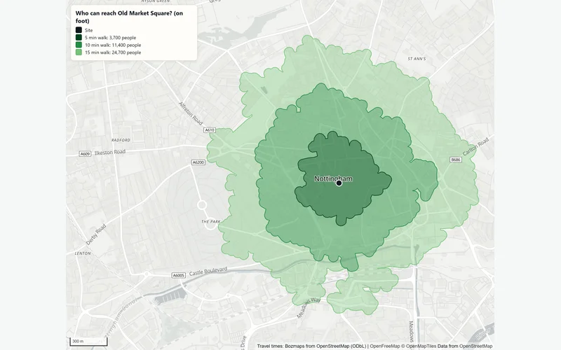
In an example run on 2 November 2026 to Old Market Square, about 3,700 people lived within a 5-minute walk and 24,700 within 15 minutes. By bike, about 95,100 lived within 10 minutes and 255,000 within 20. By car in free-flowing traffic, about 360,000 lived within 10 minutes and 836,000 within 20, an area of 359 km². The run counted residents across 2,720 Census output areas.
The Data Behind It
OpenStreetMap road and path network
OpenStreetMap contributors · Open Database Licence 1.0
Office for National Statistics, via Nomis · Open Government Licence v3.0
Output area boundaries and population-weighted centres
Office for National Statistics · Open Government Licence v3.0
| Data | Published by | Licence |
|---|---|---|
| OpenStreetMap road and path network | OpenStreetMap contributors | Open Database Licence 1.0 |
| Census 2021 tables | Office for National Statistics, via Nomis | Open Government Licence v3.0 |
| Output area boundaries and population-weighted centres | Office for National Statistics | Open Government Licence v3.0 |
Every dataset and its credit line is on data sources and licences.
What It Can't Tell You
- Drive times assume free-flowing traffic unless the busy-times setting is used; real journeys at busy times take longer.
- Public transport is not included.
- The network is only as complete as OpenStreetMap: private roads and new estates may be missing.
- People are Census 2021 residents. Workers, visitors and students away from home are not counted.
- People are counted in England and Wales; the travel-time areas themselves can be drawn wherever OpenStreetMap maps the roads.
The tools are in preview: built and tested, not yet signed off as validated. They screen a place from public data and don't replace a survey or professional advice.
Questions
Something else? Ask us.
Is a travel-time area the same as an isochrone?
Yes, it is often called an isochrone. This one is built from the roads and paths actually reached, cut at the time limit and widened, rather than a smooth shape drawn around the site, so a river or a railway without a crossing shows as a gap.
Does it allow for traffic?
Only if you ask. The default is free-flowing traffic at the speed limits, which shows how far a car can get at a quiet time. The busy-times setting runs at about 60% of the limits, closer to town traffic at busy times.
Does it include buses, trams or trains?
No. It covers walking, cycling and driving. Public transport timetables are not part of the check.
Can the areas feed other checks?
Yes. A travel-time area can be the study area for an area profile, to describe who lives within a walk or a drive. The store catchment report builds its walk and drive catchments the same way.
Can I run it on the website?
Not on the public site: travel times are worked out on the Bozmaps analysis engine, which the public site is not connected to. Tell us the site and the times you want and we run it for you.
Read Next
Who Uses It
- RetailWho lives within a walk or drive of a store, what their councils' households have to spend and how many shops compete, from Census 2021 and OpenStreetMap.
- Planning and DevelopmentPlanning constraints, area profile, travel-time reach, site finder and flood and terrain checks for a site in England, run for you and checked by a person.
- PropertyFlood exposure, planning designations, crime, deprivation and recent sales for any address in England, from official open data. For agents and investors.
Related Tools
- Store catchment reportWho lives within a walk and a drive of a store, what their councils' households have to spend, and how many shops of the same kind compete for them.
- Area profileCensus 2021 people and homes, deprivation, house prices and recorded crime around a site in England or Wales, compared with the council and the country.
- Site finderRule out protected and flood-prone land, score the rest on what matters to you, rank the best sites in an area of England and test how firm the ranking is.
Want These Checks Run for Your Sites?
Send us the addresses or the site outlines. We run the full checks on the Bozmaps engine, and a person reviews every report before it reaches you.