
EV Charger Site Finder
The EV charger site finder ranks places in an area of England for new public chargepoints. It favours streets where households have a car but probably no driveway, far from chargers mapped in OpenStreetMap and with passing traffic, and rules out flood zone 3, protected land and spots away from a public road. Each place shows why it scored well.
What You Give It
- A place: a postcode, or an area drawn on a map or uploaded. The usual search is 1.5 km around it, up to 5 km, and at most 150 km² at a time.
- How much each criterion matters, from 0 (ignore) to 5: homes with a car but probably no driveway, households with a car or van, terraced homes, distance from existing chargers, passing traffic, fair access and a public car park nearby.
- Which flood zones to rule out, whether to rule out nature and heritage designations, the distance from a charger that earns full marks (800 m as usual), how many places to list (10 as usual) and how far apart they must be (400 m as usual).
What You Get
Ranked Candidate Places
Each with its score from 0 to 1, a grid reference, the nearest road, the distance to the nearest mapped charger, the households with a car living in flats in its census area, and the traffic at the busiest nearby count point with its year.
How Firm the Ranking Is
Whether each place stays in the top 3 over 500 runs with every weight moved at random by up to 20%.
The Council's Official Count
The Department for Transport's count of public chargers in the council area, per 100,000 people and how many are rapid (50 kW or more), beside the chargers OpenStreetMap shows in the search area.
A Score Map and a Full Report
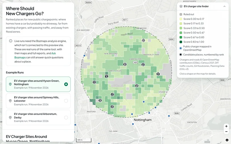
Every cell shaded by score, ruled-out land, mapped chargers and the numbered places, with the method, limits and sources.
How It Works
The EV finder uses the site finder's method with criteria for charging. The search area is split into 100 m cells. Each cell is scored from 0 to 1 on each criterion, the scores are weighted and added, and the best cells at least 400 m apart become the candidate places, so the list is spread over the area instead of ten cells side by side.
| Criterion | Usual weight | How it is scored |
|---|---|---|
| Homes with a car but probably no driveway | 3 | Households with a car or van living in a flat (Census 2021), per hectare of their census area; 1 for the densest 5% of the search area |
| Households with a car or van | 1 | Per hectare of their census area; 1 for the densest 5% |
| Terraced homes | 1 | Terraced households per hectare, a second, weaker sign of no off-street parking; 1 for the densest 5% |
| Distance from existing chargers | 2 | Straight line to the nearest public charging station in OpenStreetMap: 0 next to one, 1 at 800 m or more |
| Passing traffic | 1 | The busiest Department for Transport count point within 300 m, motorways left out: 0 under 1,000 vehicles a day, 1 at 30,000 or more, on a log scale |
| Fair access | 1 | The neighbourhood's decile in the English Indices of Deprivation 2025; more deprived scores higher unless you choose otherwise |
| Public car park nearby | 0 | 1 within 100 m of a public car park in OpenStreetMap, 0 at 400 m or more |
Ruled out: cells in flood zone 3 (or zones 2 and 3, if you choose), cells inside nature and heritage designations, and cells more than 60 m from a public road in the OpenStreetMap drive network.
Hyson Green, Nottingham
In the example run of 9 November 2026, 708 cells of 100 m covered 1.5 km around NG7 6LB and 77 (11%) were ruled out, 68 of them for having no public road within 60 m. OpenStreetMap showed 5 public charging stations in the area; the Department for Transport counted 511 public chargers across Nottingham on 1 July 2026, 154 per 100,000 people. The top place, on or near Burford Road, scored 0.90 out of 1: 1,000 m from the nearest mapped charger, with 34 households with a car living in flats in its census area and 17,843 vehicles a day on the A6130 (2025). It stayed in the top 3 in all 500 test runs.
Open this exampleThe Data Behind It
Census 2021 tables (RM001, TS045, TS044)
Office for National Statistics, via Nomis · Open Government Licence v3.0
Chargers, car parks and the road network
OpenStreetMap contributors · Open Database Licence 1.0
Department for Transport · Open Government Licence v3.0
Public charging devices by local authority
Department for Transport · Open Government Licence v3.0
English Indices of Deprivation 2025
Ministry of Housing, Communities and Local Government · Open Government Licence v3.0
Flood Map for Planning (Rivers and Sea), flood zones 2 and 3
Environment Agency · Open Government Licence v3.0
planning.data.gov.uk (MHCLG) · Open Government Licence v3.0
| Data | Published by | Licence |
|---|---|---|
| Census 2021 tables (RM001, TS045, TS044) | Office for National Statistics, via Nomis | Open Government Licence v3.0 |
| Chargers, car parks and the road network | OpenStreetMap contributors | Open Database Licence 1.0 |
| Road traffic counts (AADF) | Department for Transport | Open Government Licence v3.0 |
| Public charging devices by local authority | Department for Transport | Open Government Licence v3.0 |
| English Indices of Deprivation 2025 | Ministry of Housing, Communities and Local Government | Open Government Licence v3.0 |
| Flood Map for Planning (Rivers and Sea), flood zones 2 and 3 | Environment Agency | Open Government Licence v3.0 |
| Planning designations | planning.data.gov.uk (MHCLG) | Open Government Licence v3.0 |
Every dataset and its credit line is on data sources and licences.
What It Can't Tell You
- A screening of where to look, not a site survey: electricity network capacity, kerb space, parking rules, pavement width, land ownership and planning consent are not checked.
- Existing chargers are those mapped in OpenStreetMap, which usually misses some: there has been no free national list of chargepoint locations since the National Chargepoint Registry closed in November 2024. The council's official total from the Department for Transport is shown alongside.
- Traffic counts cover major roads every year but minor roads only at sample points, so quiet residential streets mostly score 0 on traffic. Each figure shows its year.
- 'No driveway' is estimated from homes that are flats, because no open dataset records off-street parking for each home. Census 2021 describes March 2021.
- England only for designations and deprivation; the Census figures also cover Wales.
- In the three example runs on the public site, nature and heritage designations were not checked: the national Planning Data service was not answering when they were made.
The tools are in preview: built and tested, not yet signed off as validated. They screen a place from public data and don't replace a survey or professional advice.
Questions
Something else? Ask us.
How do you know which homes have no driveway?
No open dataset records off-street parking for each home, so the finder uses the next best sign in Census 2021: households with a car or van who live in a flat. Terraced homes are a second, weaker sign, with a lower weight.
Why use OpenStreetMap for existing chargers?
Because there has been no free national list of chargepoint locations since the National Chargepoint Registry closed in November 2024. OpenStreetMap usually misses some chargers, so each result also shows the Department for Transport's official count for the council.
Can I change the weights?
Yes, in a run on the Bozmaps engine: each criterion from 0 to 5, plus the exclusions, the number of places and their spacing. The public site shows three example runs, for Hyson Green in Nottingham, Spinney Hills in Leicester and Arboretum in Derby, made with the usual weights.
Does it check grid capacity or parking rules?
No. Electricity network capacity, kerb space, parking rules, pavement width, land ownership and planning consent all need checking on the ground and with the network operator. The finder tells you where to look first.
Can you run it for my area?
Yes. Tell us the place and the weights you want and we run it on the engine and send the ranked places with the full report.
Read Next
Who Uses It
- EV ChargingRanked places for new public chargepoints: homes with a car but probably no driveway, gaps between chargers, passing traffic and flood zones ruled out.
- Planning and DevelopmentPlanning constraints, area profile, travel-time reach, site finder and flood and terrain checks for a site in England, run for you and checked by a person.
Related Tools
- Site finderRule out protected and flood-prone land, score the rest on what matters to you, rank the best sites in an area of England and test how firm the ranking is.
- Who can reach this placeHow many people live within a walk, a bike ride or a drive of a site in England or Wales, from travel-time areas drawn on the real road and path network.
- Area profileCensus 2021 people and homes, deprivation, house prices and recorded crime around a site in England or Wales, compared with the council and the country.
Want These Checks Run for Your Sites?
Send us the addresses or the site outlines. We run the full checks on the Bozmaps engine, and a person reviews every report before it reaches you.